![]()
Deed 490 104 313133
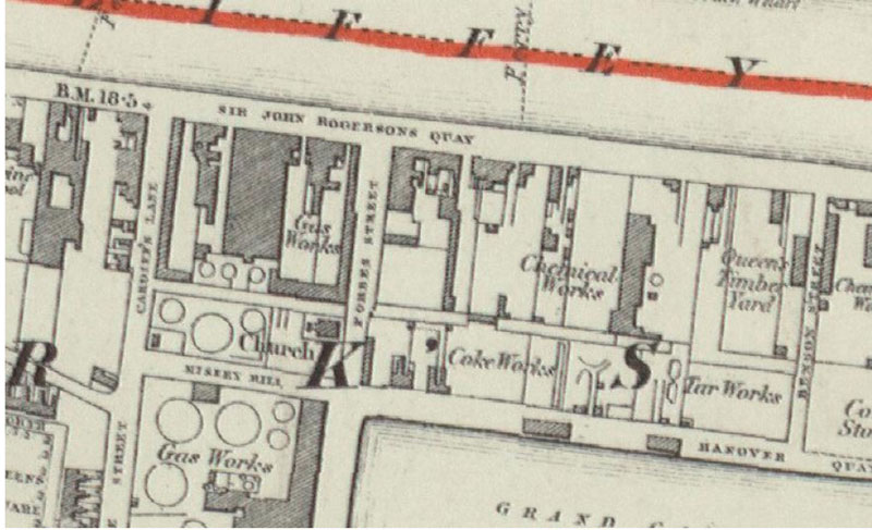
To help get oriented, check out the 1798 map by William Wilson. The pertinent quadrant is in the 2nd row from the top, and is 2nd from the right hand side. I suspect that the land in question was between Lombard St. & Ordinance St. Here is the land as mapped for the Ordnance Survey in 1844:
To the Registrar appointed by Act of Parliament for registering deeds and so forth his Dep. A Memorial of an Indented Deed of Lease bearing date the 10th day of April, 1795 made between Andrew Moller[1] of the city of Dublin merchant of the one part and Henry Jackson[2] and Robert Smythe[3] both of said City merchant of the other part whereby the said Andrew Moller for the consideration therein mentioned demise grant set over to farm let until the said Henry Jackson and Robert Smythe all that piece or parcel of ground late in the possession of Richard Molleen[4] [sic?] Joseph Higginson[5] and then in the possession of the said Andrew Moller situate lying and being on Sir John Rogerson’s Quay[6] in the County of the city of Dublin containing in breadth in the front to the said Quay 84 feet or thereabouts and in breadth in the rear the like number of feet and in breadth from front rear 221 feet 6 inches or thereabouts be the same more or less which said premises are meared and bounded on the North to the said Quay on the South to Cody’s Lane[7] in the East to the Kings Watch House[8] and on the West to Brakens Lane[9], together with the appurtenances thereto belonging or in any way in any wise appertg in as full and ample as the said Andrew Fuller[10] [sic?] then held and enjoyed to the same and as the same or more particularly delineated and described in map or survey thereof thereunto annexed may appear to hold on to the said Henry Jackson and Robert Smythe their exons admons or assigns from the 25th day of March then last for the full end term of 74 years from thenceforth fully to be completed and ended at the yearly rent of £150 payable half-yearly above taxes as therein mentioned and subject to the several covenants and agreements on the tenant or lessees part to be observed done and performed which said lease is duly executed by the subscribing parties thereunto, and this Memorial is also duly executed by the said Andrew Moller and said deed and Memorial are witnessed by Robert Gray[11] and Henry Vernon[12] both of the city of Dublin gent and Andrew Moller . [SEAL]. signed, sealed and delivered in presence of Robert Gray Henry Vernon […?] above named Henry Vernon maketh oath and saith that he is a subscribing witness to the indented deed of which the above writing is a Memorial to said Memorial and saith that he saw Andrew Moller Henry Jackson and Robert Smythe above named duly execute the same that he also saw said Andrew Moller sign and seal the above Memorial and saith that the said Henry Vernon subscribed and is a witness to said deed and Memorial is this deponents handwriting and that he delivered said deed and Memorial to John Moore[13] Esq. Deputy Registrar on the 10th day of April 1795 at or near [?] 12 of the [?] the [?] Henry Vernon sworn before me this day of [?] 1795 John Moore Deputy Registrar. [1] Andrew MOLLER, Merchant in Dublin · I suspect a link with Deed: 421-211-268932 1789 Apr. 23. Btw Ann BINNS widow, Andrew MOLLER Merchant, William PIKE, Plumber, James JACKSON, Glass and Delph Ware seller all of City of Dublin.... last will and testament of Jonathon BINNS late of City of Dublin... piece of land near paper mill.. · This is likely the deed referenced in the Pat Purcell Papers. Indenture made on 28th May 1789 between Ann Binns, Widow, Andrew Moller, Merchant, William Pike, Plummer and James Jackson, China, Delph and Glass Wareseller of one part and Michael Lennon of the County of Dublin, Farmer of the other part. Hath let Farm to Michael Lennon situated on the east side of the road leading from Dublin to Kilmashoge bounded on the East by land belonging to the Right Honourable David Latouche and on the North by the United Bretherns Burying Ground for the term of Six years. (signed with Seals attached), Ann Binns, Andrew Moller, William Pike, James Jackson, Michael Linen [aka LENNON]. Signed, Sealed and Delivered in the presence of David Donaldson and James D [ ? ]. · He was included as one of the subscribers to The Antiquities of Ireland published in 1804. [2] Henry JACKSON. I need to do a bit more work to be sure which Henry JACKSON, merchant of Dublin this one is. My hunch is that it is the Henry JACKSON (1750-1817) who fled to America as a result of his United Irishmen activities. [3] Robert SMYTHE [4] Richard MOLLEEN [5] Joseph HIGGINSON [6] Sir John Rogerson’s Quay.
[7] Cody’s Lane. I have been unable to locate a mention of this name. [8] Kings Watch House. In the 1798 map by William Wilson, The King’s Stores are shown on the other side of a street called Ordinance Street. [9] Braken’s Lane aka Bracken’s Lane – it seems to have intersected with Townsend Street. I suspect it was between Lombard St. & Ordinance St. Earlier the area was known as Lazar’s Hill. Dublin Street Names, Dated and Explained. Rev. C.T. M’Cready (Curate of S. Auden’s and minor Canon of S. Patrick’s Cathedral, Dublin) Hodges, Figgis, and Co., Dublin. 1892. p.11 NOTE: There are other leases to JACKSONs which also mention Lazer’s Hill. At the time of Griffiths Valuations, most of the lots on Brackens Lane are owned by Patrick CURTIN, and there was a slaughterhouse owned by Thomas HUGHES. [10] Andrew FULLER. I suspect this is a clerical error. [11] Robert GRAY [12] Henry VERNON [13] John MOORE
|
Site Map | Legal Disclaimer | Copyright
© 2006-2023 Sharon Oddie Brown